File:Jerez.svg
Jump to navigation
Jump to search


Size of this PNG preview of this SVG file: 611 × 600 pixels. Other resolutions: 245 × 240 pixels | 489 × 480 pixels | 782 × 768 pixels | 1,043 × 1,024 pixels | 2,086 × 2,048 pixels | 1,085 × 1,065 pixels.
Original file (SVG file, nominally 1,085 × 1,065 pixels, file size: 30 KB)
Summary
| Description |
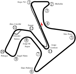
English: Track map of Circuito Permanente de Jerez. |
| Date | |
| Source | Own work |
| Author | Will Pittenger |
| Other versions |
|

| Camera location | | View this and other nearby images on: OpenStreetMap |
|---|
Licensing
| I, the copyright holder of this work, release this work into the public domain. This applies worldwide. In some countries this may not be legally possible; if so: I grant anyone the right to use this work for any purpose, without any conditions, unless such conditions are required by law. |
File history
Click on a date/time to view the file as it appeared at that time.
| Date/Time | Thumbnail | Dimensions | User | Comment | |
|---|---|---|---|---|---|
| current | 04:35, 29 May 2022 | | 1,085 × 1,065 (30 KB) | wikimediacommons>Sentoan | Cambios menores curvas 7 y 11 |
File usage
The following 2 pages use this file: